


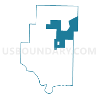
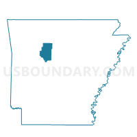
Jackson Voting District, Pope County, Arkansas
About
Outline

Summary
| Unique Area Identifier | 527727 |
| Name | Jackson Voting District |
| County | Pope County |
| State | Arkansas |
| Area (square miles) | 101.43 |
| Land Area (square miles) | 101.40 |
| Water Area (square miles) | 0.03 |
| % of Land Area | 99.97 |
| % of Water Area | 0.03 |
| Latitude of the Internal Point | 35.54081360 |
| Longtitude of the Internal Point | -92.93988560 |
Maps

Graphs
Select a template below for downloading or customizing gragh for Jackson Voting District, Pope County, Arkansas


Neighbors
Neighoring Voting District (by Name) Neighboring Voting District on the Map
- Center Voting District, Pope County, AR
- Craig Voting District, Van Buren County, AR
- Freeman Voting District, Pope County, AR
- Griffin Voting District, Pope County, AR
- Jackson Hector Voting District, Pope County, AR
- Liberty Voting District, Pope County, AR
- Phoenix Voting District, Pope County, AR
- Smyrna Voting District, Pope County, AR
- Wheeler Voting District, Van Buren County, AR
Top 10 Neighboring County Subdivision (by Population) Neighboring County Subdivision on the Map
- Jackson township, Pope County, AR (1,110)
- Griffin township, Pope County, AR (839)
- Liberty township, Pope County, AR (837)
- Center township, Pope County, AR (523)
- Wheeler township, Van Buren County, AR (336)
- Phoenix township, Pope County, AR (313)
- Liberty township, Van Buren County, AR (240)
- Smyrna township, Pope County, AR (187)
- Freeman township, Pope County, AR (102)
Top 10 Neighboring Place (by Population) Neighboring Place on the Map
Top 10 Neighboring Unified School District (by Population) Neighboring Unified School District on the Map
- Clinton School District, AR (9,129)
- Dover School District, AR (7,969)
- Hector School District, AR (3,627)
Top 10 Neighboring State Legislative District Lower Chamber (by Population) Neighboring State Legislative District Lower Chamber on the Map
Top 10 Neighboring State Legislative District Upper Chamber (by Population) Neighboring State Legislative District Upper Chamber on the Map
Top 10 Neighboring 111th Congressional District (by Population) Neighboring 111th Congressional District on the Map
Top 10 Neighboring Census Tract (by Population) Neighboring Census Tract on the Map
- Census Tract 9510, Pope County, AR (4,359)
- Census Tract 4602, Van Buren County, AR (3,876)
- Census Tract 9507, Pope County, AR (3,871)